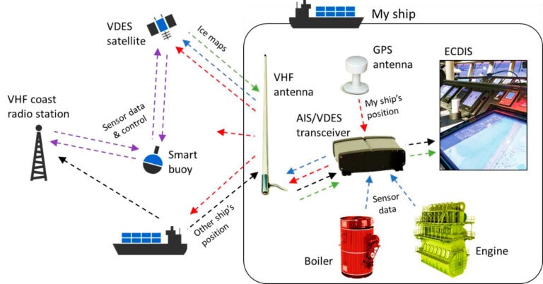
VDES (VHF Data Exchange System) is the second generation of the popular AIS technology used for vessel tracking and other navigational and safety-related purposes by more than 300,000 vessels globally. As illustrated, AIS allows ships to broadcast their position (along with id, course, and speed). This is picked up by other ships, by coastal VHF radio networks, and today also by satellites.
• Automation and digitalization
• Savings and simplifications
• Better safety & protection solutions
• Enable e-Navigation service
• Better situational awareness
• ITU recommendation (ITU-R M.2092)
• Becoming an IMO requirement (SOLAS IV+V)
• Affordable ship equipment
• Global coverage via satellite
• Extremely simple and robust
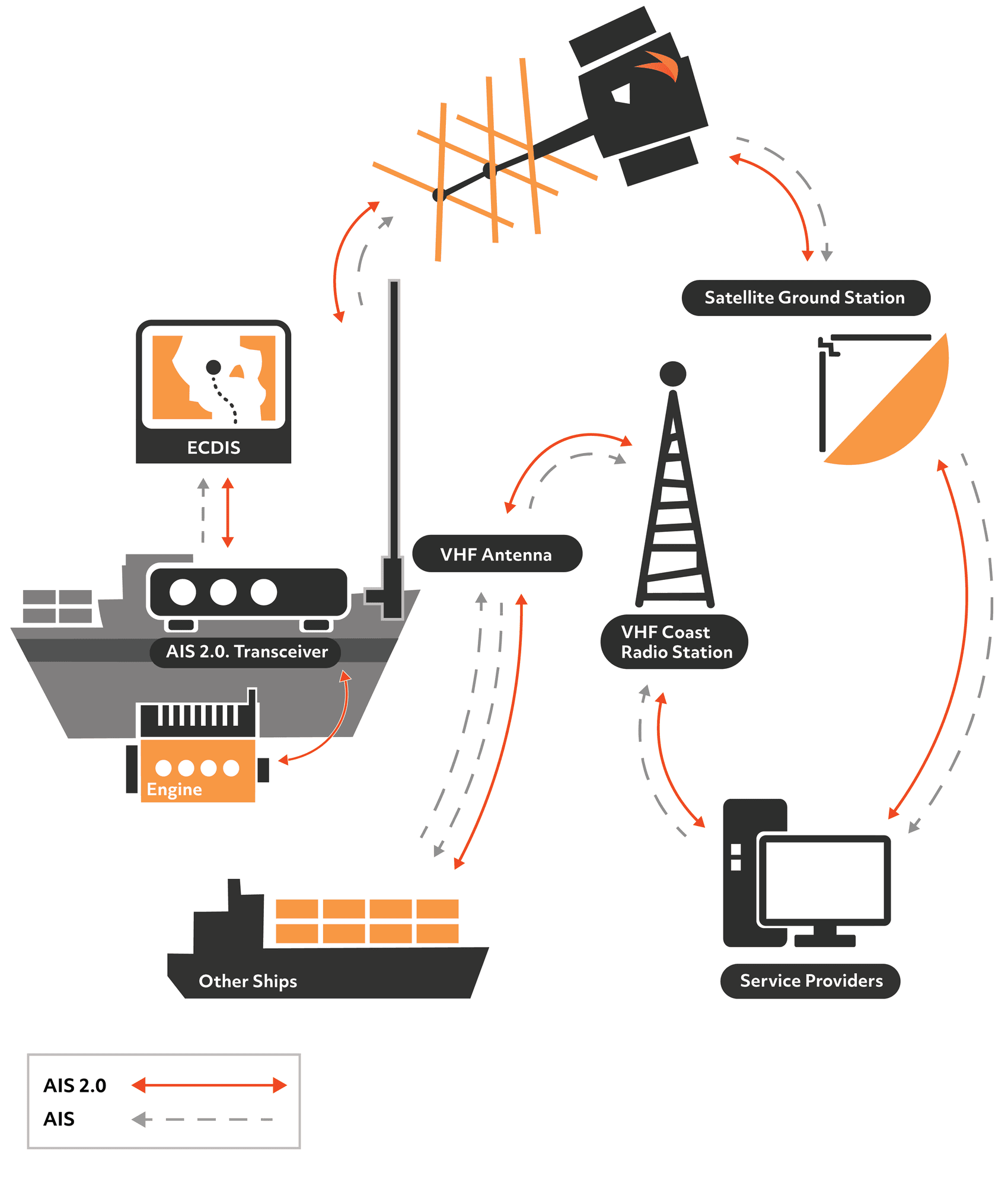
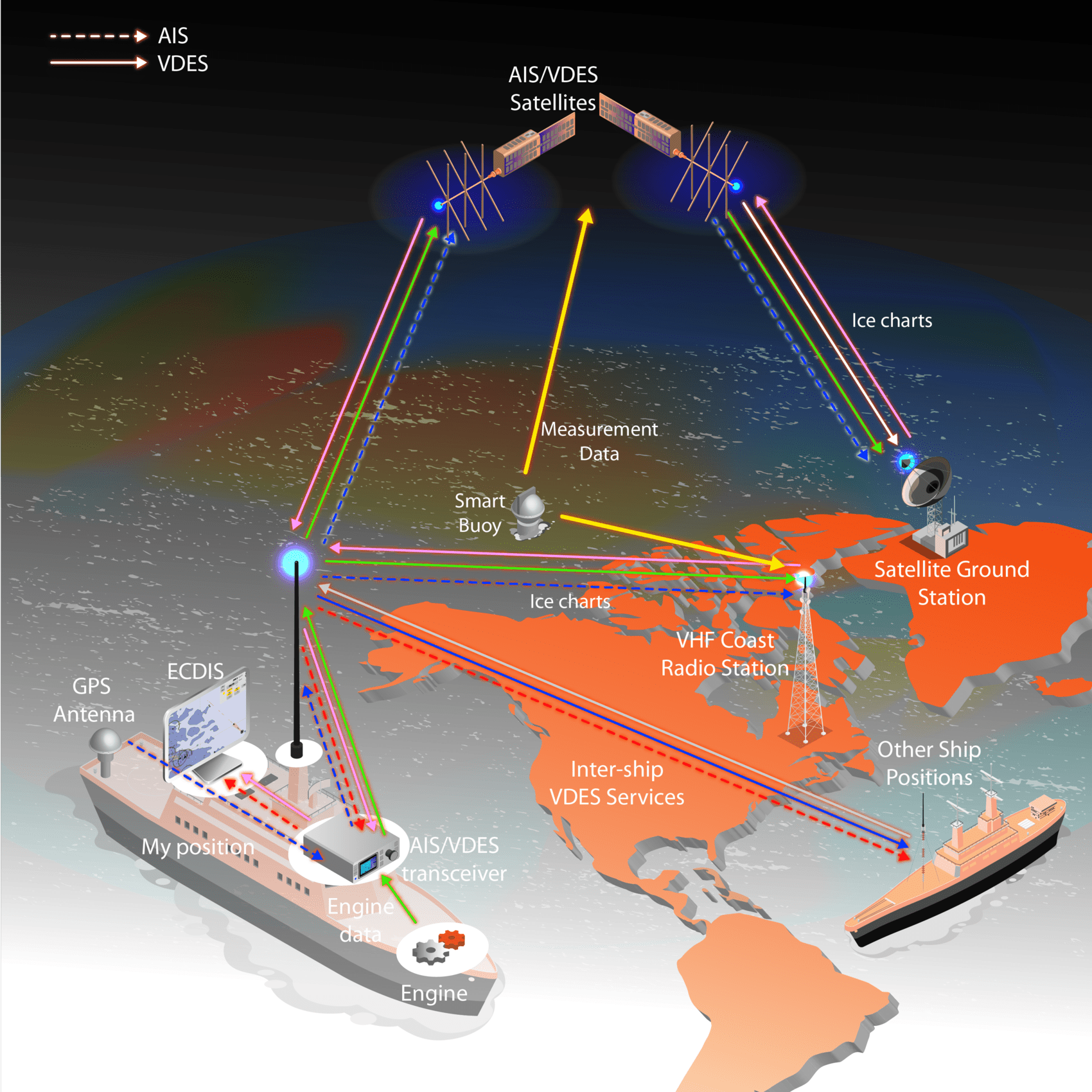
Over the past decade, the maritime industry and authorities have identified needs for more digitalization. This has been captured in the IMO e-Navigation strategy.
VDES is the new communication solution to implement the e-Navigation strategy. VDES is an extension to AIS, adding two-way data channels over VHF. By using special satellite channels (up and down), every ship with a VHF antenna is able to communicate globally. This figure illustrates a few VDES services such as “Ice charts”, “Engine monitoring”, and “Environmental monitoring” using smart buoys.
The VDES system consists of these two sub-systems working together:
During 2025 Sternula is conducting a worldwide demo project in collaboration with partners with an interest in utilizing the new AIS 2.0 technology.
You can sign up to be a Worldwide AIS 2.0 Demo partner. The sign-up is an indicative commitment only since the exact scope and costs for your involvement cannot be settled at the current stage.
AIS 2.0 is the combination of current AIS, which is a carriage requirement under the IMO SOLAS (Safety-of-Life-at- sea) convention, and the new VDES (VHF Data Exchange System) standard. AIS is deployed today in more than 200,000 vessels. VDES adds new secure data channels, significantly more capacity, and global two-way connectivity via satellite.
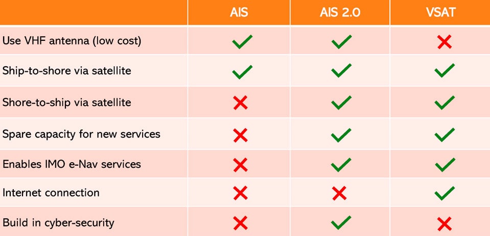
The satellite element, which is what Sternula offers, is known as VDE-SAT. AIS 2.0 works over the existing VHF antenna and a newer AIS terminal (no extra satellite antenna onboard!). AIS 2.0 by design does not allow IP connections.
This means that critical onboard systems, such as the ECDIS charting system, engines, and power systems, that could be the target of cybercrime, espionage, and terrorism may be connected securely to shore services via AIS 2.0.
At an open workshop in Accra together with the Ghana Maritime Authority and 7 other maritime nations attending online, Lars Moltsen, the Founder and CEO of Sternula, made a presentation of “AIS 2.0” as the recommended name for VDES in the communication with end users (like the mobile industry uses 3G, 4G, and 5G instead of the technical names for those standards).
Lars Moltsen also presented a few use cases that may be offered over AIS 2.0 in short and medium term, and he opened the door for more collaboration and involvement in standardization.
AIS was developed in the 1990s and it marked the beginning of the digitalization of the maritime industry. Figure 1 illustrates how AIS allows ships to share messages containing id, current position, course, and speed with other ships as well as with coast stations. More recently, since around 2010, AIS satellites have been deployed for global AIS reception.
AIS allows the mariner to plot and track nearby ships automatically in the onboard ECDIS (Electronic Chart Display and Information System). This is a very effective collision-preventive tool, increasing the visualization of sailing and enabling more effective radio communication between ships. Consider this example voice communication: “Dutch trawler, Eva-Maria, confirm that you will be turning starboard to prevent collision”. In this message, the name and nationality of the targeted ship are known because of AIS. Before, the sailor had to use a more indirect language: “Trawler, 12 miles North of Hanstholm sailing East, confirm that you will be turning starboard to prevent collision”.
On land, by using AIS data, shipping companies are able to monitor the exact location of each ship in their fleet, and public information systems have emerged, enabling anyone to check out ships in their local waters.
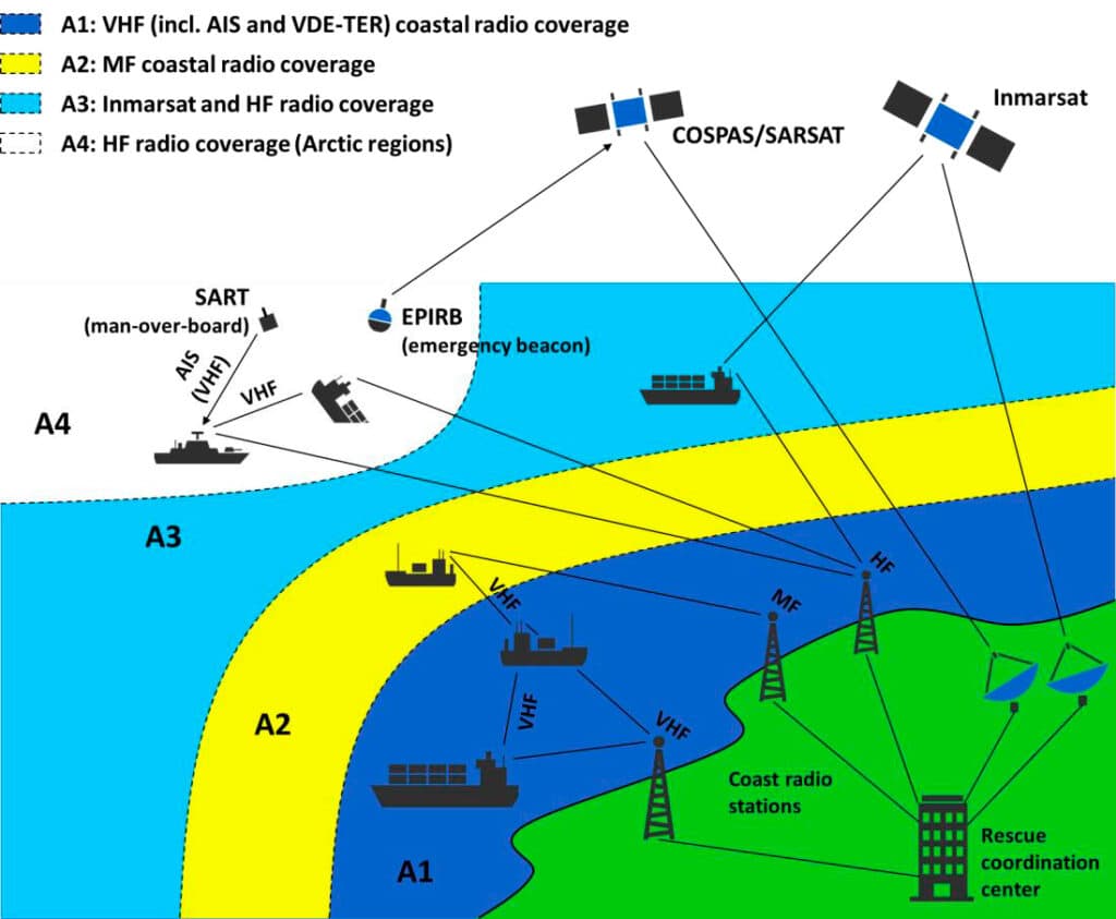
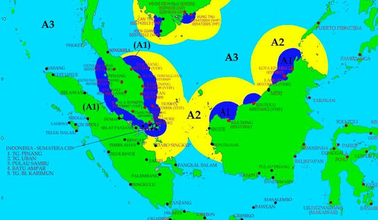
The International Maritime Organization (IMO) is the United Nations’ agency for maritime navigation and safety regulation. IMO maintains the SOLAS (Safety of Life at Sea) convention which specifies required communications infrastructure by the industry and authorities under the GMDSS (Global Maritime Distress and Safety System). The figure illustrates the main communications systems of GMDSS as well as its coverage areas (A1-A4).
AIS is an integrated element of GMDSS. AIS transceivers exist as both Class A and Class B variants with different transmit power and different levels of information. Class A is mandatory under SOLAS for passenger ships as well as for all ships above 300 gross tonnage.
At the top of the figure, the AIS-based SART (Search and Rescue Transponder) system can be seen. This is used for plotting “man over board” directly in the ECDIS of nearby ships for efficient rescue operations.
AIS also includes ASM (Application-Specific Messaging) for pushing small text messages containing e.g. water levels in canals or weather information by the local authority. ASM was added to AIS in 2001, and in 2010, the use of ASM was standardized by the “IMO Safety of Navigation Circular 289”. ASM has become very popular and is causing severe congestion of the AIS system in many regions.
Despite the advancements in navigational efficiency and maritime safety from AIS and other systems under GMDSS, too many fatal events at sea are still seen. Moreover, the development towards more Arctic traffic and autonomous shipping demands new systems and digital services. Maritime authorities and the maritime industry have captured a comprehensive set of such demands in the IMO “e-Navigation strategy”.
Because e-Navigation cannot be realized using current GMDSS systems, the new VDES standard has been specified. VDES is “AIS on steroids”, delivering higher capacity and true global two-way data connectivity for the ship bridge. New data channels using advanced modulation schemes have been defined, including robust satellite uplink and downlink channels. Terrestrial VDES (ship-to-ship and ship- to-shore) is defined as VDE-TER and satellite-based VDES (ship-to-satellite) as VDE-SAT.
VDES will allow for a broad range of new e-Navigation services as illustrated by the figure below.
These are just a few examples covering uplink and downlink, monitoring/tracking, and remote control. Many more solutions and offerings, most of which do not exist today, will be enabled by VDES.
Considering that many e-Navigation services will demand close-to-realtime or at least periodic (e.g. hourly) connectivity globally, the VDE-SAT option will be very important. This can be seen by the figure below which shows the current availability of GMDSS systems in Malaysian waters. Since VDES is VHF-based, VDE-TER coverage will only be available in area A1. So, VDE-SAT will be needed for coverage in areas A2 and A3 (as well as A4 in Arctic regions).
VDES will be the future primary connectivity option for e-Navigation services and we predict that VDES will replace AIS as a mandatory GMDSS system within the coming decade.
The upgrade from AIS to VDES on board the ship only requires exchanging the transceiver box, whereas the antenna, power and connections to the ECDIS do not have to be changed from today’s state of the art. This ensures much lower cost and wide applicability compared to alternative solutions based on e.g. global satellite networks. These depend on proprietary and expensive dish antennas, which are great for broadband internet connectivity in the high-end segment of approximately 50,000 vessels. For the fishing fleet in many parts of the World and for the low-end leisure segment, however, the cost of such systems is not an option. Also, the scalability of new smart buoy solutions will demand low-cost equipment and connectivity.
Another very important feature is that VDES connects directly to bridge equipment such as the ECDIS. VDES is a closed and secure system where services are approved by ship crew and authorities. Open internet-based connectivity cannot be used directly with bridge equipment. Using satellite broadband systems would demand additional layers of cyber security since the risk of intrusion from hackers or malware would be high.
Today there are more than 200,000 vessels reporting their position using “Class A” or “Class B” AIS transceivers. With new e-Navigation services, solutions, and systems enabled by VDES, we predict that more than 500,000 ships and buoys will be connected via VDES over the coming 10 years. This growth will also be driven by the ongoing penetration of both AIS and VDES in developing countries.
VDES solves the demands of coastal administrations and industry and can be expected to facilitate a digital disruption of the maritime sector. The technology will allow for localized, approved, secure realtime data exchange between close-by ships, authorities, buoys, and service providers world-wide.
VDES can be viewed as a special maritime safety/navigation IoT standard. We expect that the growth rate of VDES will be comparable within its own niche to the growth rates of terrestrial IoT systems such as LoRa, Sigfox, and NB-IoT. Therefore, it is important for maritime authorities, shipping companies, and solution/service providers to start preparing now for the opportunities of VDES.

Danalien 1, 2 tv, DK-9000
Aalborg, Denmark